Last 10 volume scans
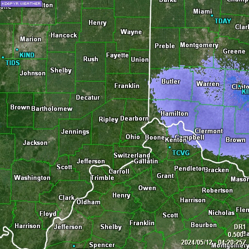
Wilmington, OH NWS (KILN) Doppler Radar Loop using GRLevel3 Software
Last 10 volume scans
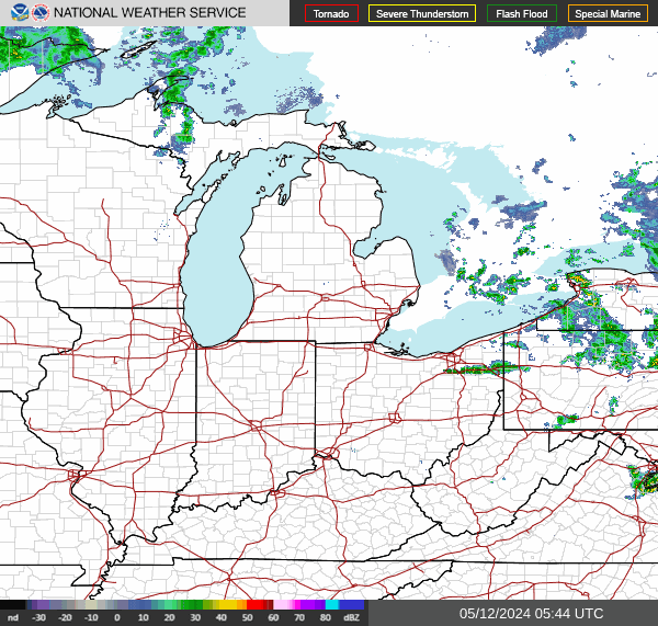
Great Lakes Regional Radar
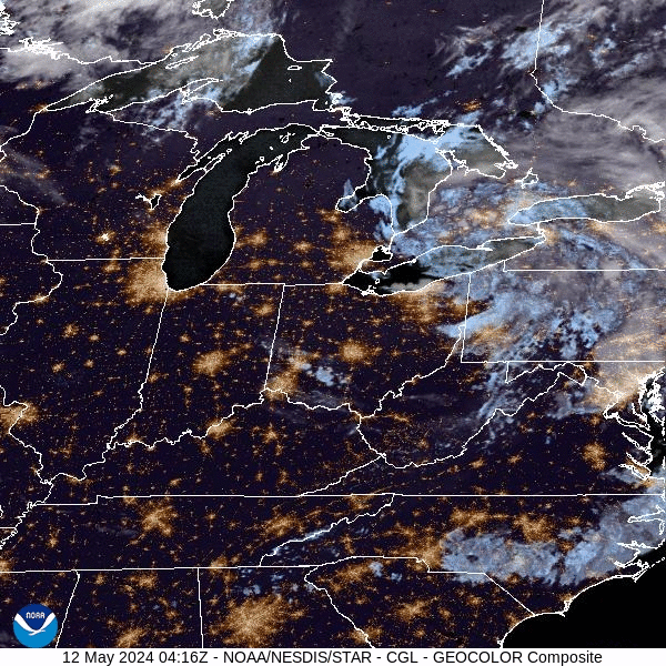
GOES East GeoColor
National Weather Service Regional Observations
| Station | Location | Date | Time | Weather | Temp | RH | Wind Direction | Wind Speed | Pressure | Dewpoint | Visibility |
|---|---|---|---|---|---|---|---|---|---|---|---|
| KCRW | Charleston, WV | Apr 18 2024 | 7:54 am EDT | Partly Cloudy | 62°F | 80% | West | 4.6 mph | 30.06 in. | 55.9°F | 10.00 mi. |
| KORD | Chicago, IL | Apr 18 2024 | 6:51 am CDT | Mostly Cloudy | 49°F | 80% | North | 0.0 mph | 30.05 in. | 43.0°F | 10.00 mi. |
| KCVG | Cincinnati, OH | Apr 18 2024 | 7:52 am EDT | A Few Clouds | 52°F | 83% | West | 3.5 mph | 30.08 in. | 46.9°F | 10.00 mi. |
| KCLE | Cleveland, OH | Apr 18 2024 | 7:51 am EDT | Overcast | 56°F | 70% | West | 13.8 mph | 29.99 in. | 46.0°F | 10.00 mi. |
| KCMH | Columbus, OH | Apr 18 2024 | 7:51 am EDT | Partly Cloudy | 55°F | 74% | West | 6.9 mph | 30.05 in. | 46.9°F | 10.00 mi. |
| KDAY | Dayton, OH | Apr 18 2024 | 7:56 am EDT | A Few Clouds | 52°F | 86% | West | 8.1 mph | 30.08 in. | 48.0°F | 10.00 mi. |
| KIND | Indianapolis, IN | Apr 18 2024 | 7:54 am EDT | A Few Clouds | 51°F | 83% | North | 0.0 mph | 30.07 in. | 46.0°F | 10.00 mi. |
| KJKL | Jackson, KY | Apr 18 2024 | 7:53 am EDT | Fog/Mist | 61°F | 97% | North | 0.0 mph | 30.10 in. | 60.1°F | 6.00 mi. |
| KTYS | Knoxville, TN | Apr 18 2024 | 7:53 am EDT | Overcast | 59°F | 83% | West | 4.6 mph | 30.12 in. | 54.0°F | 10.00 mi. |
| KLEX | Lexington, KY | Apr 18 2024 | 7:54 am EDT | Fair | 56°F | 81% | North | 0.0 mph | 30.09 in. | 50.0°F | 10.00 mi. |
| KSDF | Louisville, KY | Apr 18 2024 | 7:56 am EDT | Mostly Cloudy | 60°F | 65% | Northeast | 6.9 mph | 30.09 in. | 48.0°F | 10.00 mi. |
| KPAH | Paducah, KY | Apr 18 2024 | 6:53 am CDT | Fog/Mist | 65°F | 87% | Southeast | 3.5 mph | 30.03 in. | 61.0°F | 5.00 mi. |
| KPIT | Pittsburgh, PA | Apr 18 2024 | 7:51 am EDT | Overcast | 57°F | 72% | West | 10.4 mph | 29.99 in. | 48.0°F | 10.00 mi. |
| KSTL | St. Louis, MO | Apr 18 2024 | 6:51 am CDT | Mostly Cloudy | 61°F | 60% | Southeast | 16.1 mph | 29.97 in. | 46.9°F | 10.00 mi. |
| KPBI | West Palm Beach, FL | Apr 18 2024 | 7:53 am EDT | Mostly Cloudy | 75°F | 69% | Southeast | 6.9 mph | 30.09 in. | 64.0°F | 10.00 mi. |
| KILN | Wilmington, OH | Apr 18 2024 | 7:54 am EDT | Fair | 53°F | 74% | West | 6.9 mph | 30.07 in. | 45.0°F | 10.00 mi. |
These are regional hourly observations reported by the National Weather Service. The observations are usually made between 50 and 59 minutes past the hour and are usually updated by 15 minutes past the hour.
45,971 Views
| Time: Thu 18-Apr-2024 at 08:47 EDT (Thu 18-Apr-2024 at 12:47 UTC) | Page Modified: 10/27/2022 4:05:45 PM (PID:12) |